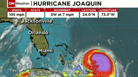
With the help of winds as fast as 130 mph, Juaquin became the strongest hurricane of the season. The Hurricane is expected to get stronger on Friday and the winds with go up to 140 mph. This information was obtained from the National Hurricane Center.
The official forcast for the Hurricane, at 5 p.m., shifted the path of the storm almost entirely off the Coast. Only coastal areas of southern England are safe from the Hurricane. A mojority of the forecast are now agreeing on the track farther away from the United States. Still flooding is a major concern becuase of rain linked to Hurricane Joaquin.
A lot of the Eastern United tates has received rain and now some of the areas are expecting more rain.
This will result in severe flooding, especially in areas like outh Carolina where there has been up to 20 inches of rain predicted.
No comments:
Post a Comment